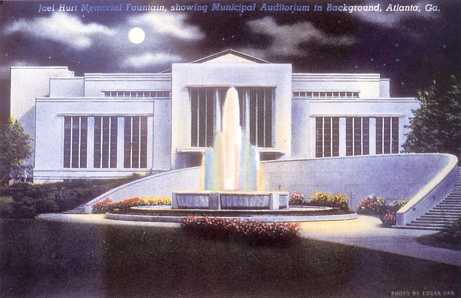
Figure 1. Post Card view of fountain at Hurt Park and the Municipal Auditorium, ca. 1941. (from Robert M. Craig, Atlanta Architecture, Art Deco to Modern Classic, 1929-1959) |
When Hurt Park opened in 1940, it was the first park in downtown Atlanta since the 1860s and represented one of the great achievements of Mayor William B. Hartsfield’s first administration. Over a five year period between 1937 and 1942, the City of Atlanta transformed its aging Municipal Auditorium and the surrounding area into a civic center that befitted Atlanta’s rising status as a convention center. This New Deal-era civic center, with Hurt Park as its formal forecourt, served the City for thirty years until the present Civic Center was created north of downtown in 1968.
Funded in part by the Woodruff Foundation and planned with the assistance of the Work Progress Administration (WPA), Hurt Park and its fountain were designed by the noted landscape architect William Crooks Pauley (1893–1985) and were among downtown Atlanta’s most popular attractions throughout the 1940s and 1950s. Hurt Park was one of only a handful of important con-struction projects in downtown Atlanta during the Great Depression, and it remains one of the City’s most important landmarks from the period between the two World Wars.
A City Block
Located just two blocks east of Five Points, the approximately 1.6 acres of land that are now Hurt Park are part of Land Lot 52, 14th District, one of four land lots (51, 52, 77, and 78) that encompass all of the present downtown business district. When Atlanta’s third rail line was completed in 1846 and it became clear to the few hundred residents here that the town would continue to grow, the owners of these land lots quickly subdivided their property and laid out streets that created the original plan of the City of Atlanta. Land Lot 52 was owned by Lemuel P. Grant, then living in Decatur but soon to be one of Atlanta’s best-known residents.
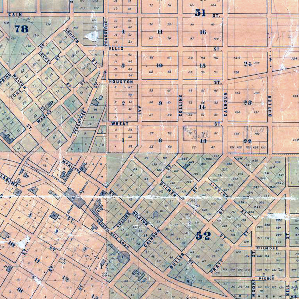
Figure 2. Detail from Vincent’s map of Atlanta, 1853, showing land lot numbers as well as city block and lot numbers. The future site of Hurt Park is at the center of this image. |
In order to maximize their land values, Grant and the other owners subdivided their property and, rather than orienting the new roads to the points of the compass, laid off streets that were oriented to existing roads and to the railroad as it angled across the individual land lots. As a result of their actions, wherever these artificial street grids intersected adjacent land lot lines or existing roads, a series of unique triangular blocks was created. The intersections of Gilmer, Collins (now Courtland), and Ivy (now Peachtree Center Avenue) Streets, formed the initial triangular imprint for the Hurt Park site, which was completed in 1886 when Edgewood Avenue was laid out along the line between Land Lots 51 and 52.
Gilmer Street, which runs from northwest to southeast parallel with the railroad, intersected Collins Street on the crest of a small hill and was named for George Rockingham Gilmer (1790–1859), who oversaw construction of the fort at Standing Peachtree in 1813 and was Governor of Georgia as Terminus was being staked out in 1837. On the southeastern side of the Hurt Park site was Collins Street, named for James A. Collins, one of the City’s early merchants. In the wake of the transformation of the southern end of the street into a red-light district after the Civil War, property owners petitioned to have the northern run of the street renamed Courtland Street in the 1880s. Ivy Street, which clips the western end of the Hurt Park triangle, was named for Hardy Ivy (1780–1842), Atlanta’s “first” pioneer and owner of Land Lot 51 in the 1830s and 1840s.
Hurt Park comprises most of four original city lots (62, 159, 160, and 161), each of which contained around a half acre of land intended as residential building lots. Lots 62 and 161 were triangular lots at either end of the park site while lots 159 and 160 were more-conventional rectangular lots on Gilmer at the corner with Collins. As early as the 1850s and certainly by 1868, these lots and several others in the area were owned by the Lynches, a large Irish family that had immigrated from County Meath in the early 1830s and settled in Atlanta in the late 1840s. One of the five brothers in this family, Patrick Lynch (1819–1871), was a “rock contractor” who operated a quarry on Rock Street and is credited with constructing the foundation of the Shrine of the Immaculate Conception (1869) and the first Fulton County Courthouse (1854). Peter Lynch (1828–1903), the younger brother, operated a well-known saloon in Atlanta in the nineteenth century. John Lynch (1817–1880) and his brother James Lynch (1823–1899) worked as common railroad laborers prior to their arrival in Atlanta, but by the time of the Civil War both were prominent merchants in the city. [1]
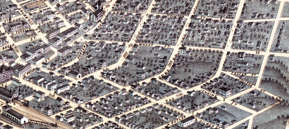
Figure 3. Ruger’s bird’s-eye view of Atlanta, 1871, showing the open blocks across which Joel Hurt would later run Edgewood Avenue. |
|
|---|
James Lynch built a house on the present Hurt Park site, probably at the corner of Gilmer and Collins, as did Michael and probably Patrick as well. Their houses may have survived the Civil War, as many did in that part of town, but in any case, five houses, stables, and other structures, some of them constructed of brick, had been built by the Lynches along the north side of Gilmer Street by 1871. Many of those buildings remained standing in 1939.
Joel Hurt
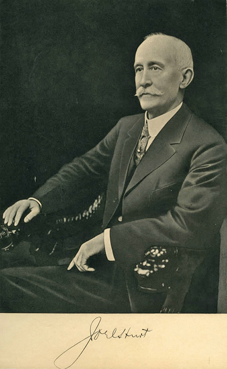
Figure 4. Joel Hurt around 1900. (Atlanta History Center) |
The park was named for Joel Hurt (1850–1926), one of the most influential figures in Atlanta in the late nineteenth and early twentieth centuries. Born at Hurtsboro, Alabama, southwest of Columbus, Georgia, in 1850, Hurt and his brother Fletcher were trained as civil engineers and spent the early 1870s surveying new railroads in the West. By 1875, Joel Hurt was in Atlanta where some of his father’s cousins had bought adjoining plantations on the Georgia Railroad in the vicinity of present-day Inman Park before the Civil War.
Hurt quickly became active in real estate and insurance, organizing the Atlanta Building and Loan Association in 1875, the first of its kind in the city. In 1884, he formed the East Atlanta Land Company to develop suburban real estate east of the city, on which he would create the city’s first garden suburb, Inman Park, and begin development of Druid Hills. He also built the city’s first steel-framed skyscraper, the old Equitable Building, which was completed in 1891. Connecting downtown to Inman Park would be the city’s first electric streetcar line, which began operation in August 1889 and came, as one reporter enthused, like “a benediction to drivers who have clattered over stones and dodged vehicles in town in a vain effort to get sweetness and light in their daily ride.” [2]
Construction of the planned electric street car line between downtown and Inman Park, however, required the creation of Edgewood Avenue, which was perhaps the most daunting task undertaken by Hurt’s East Atlanta Land Company. While there had always been a “Five Points” downtown where Decatur and Marietta Streets intersected Peachtree, the other street that created the intersection ran only one block to Pryor Street (now Park Place) where it then followed the present route of Exchange Place to its dead end at Ivy Street (Peachtree Center Avenue). Line Street, as it was called, did nothing to allow east-side commuters easy access to and from downtown. In order to open his boulevard to Inman Park, Hurt persuaded the City to condemn the built-up land along the land lot line from Pryor to Butler Streets. With that, Line Street could be connected to Foster Street, which followed the same line east of Butler Street and which Hurt was able to improve and extend into Inman Park. He agreed to pay for any costs to the city above $20,000 in clearing the land, while the East Atlanta Land Company would foot the entire bill for constructing the new avenue. After considerable dissension, the City finally agreed to the project and, in 1888, set about razing or moving ninety-four buildings so that Joel Hurt could build Edgewood Avenue. [3]
Although his house was not removed, James Lynch did lose part of his lot at #12 Gilmer Street to this condemnation process in 1885. Four years later, he either remodeled his late brother Michael’s old house at 34 Gilmer Street or built an entirely new house on that site. In 1890, he sold the remainder of his property at the western end of the block to Joel Hurt’s East Atlanta Land Company, which proceeded to construct a three-story brick office building on the site, called the Exchange. [4]
Named for the community that had grown up in the 1870s and ‘80s along the railroad in the vicinity of the Hurt cousins’ plantations, Edgewood Avenue was opened in September 1888, with great fanfare and with speeches by Gen. John B. Gordon, Henry Grady, and Joel Hurt himself. A year later, the city’s first electric street cars began their run out the double tracks on the avenue, taking fifteen minutes to make the two-mile trip from Five Points to the Trolley Barn in Inman Park. The streetcar line was an instant success. An observer described the new avenue in 1891: “Standing in the heart of the city . . . the eye sweeps eastward in an arrow line to the very brow of the fair suburban queen, Inman Park. . . The whole avenue from end to end has been planted in the choicest shade trees.” [5]
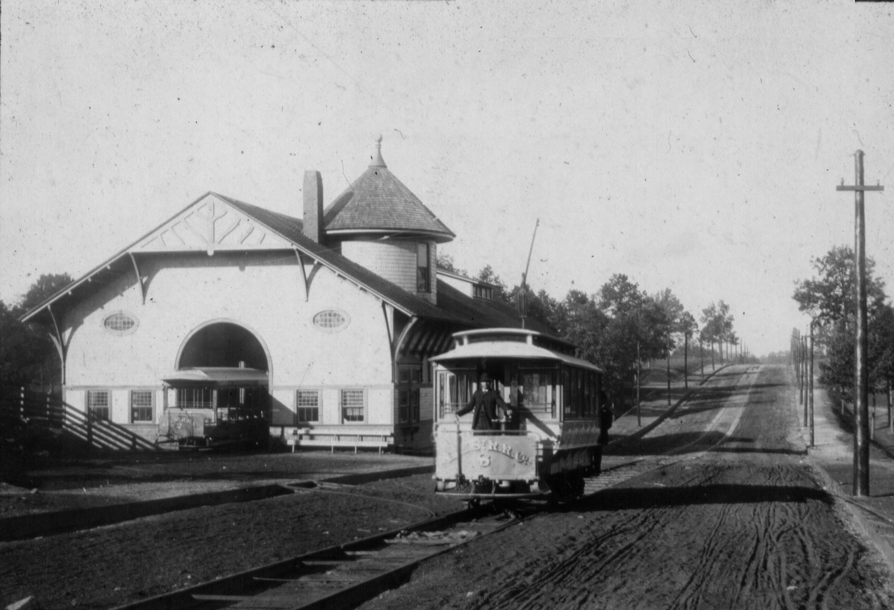
Figure 5. The Atlanta and Edgewood street car, ca. 1890, at the company's trolley barn in Inman Park. |
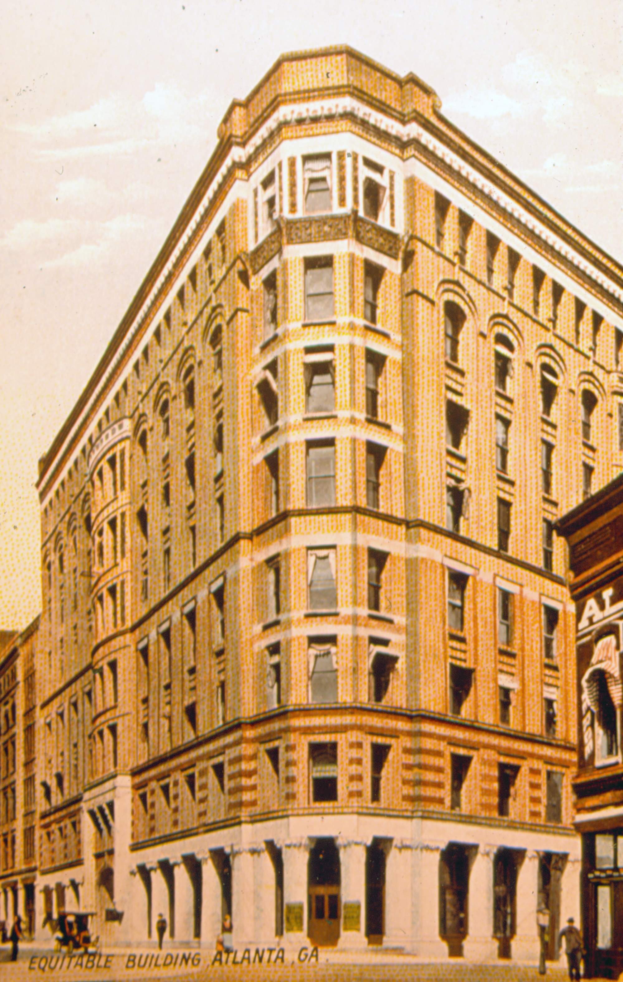
Figure 6. The Equitable Building, the city's first steel-framed skyscraper, built by Joel Hurt in 1890. |
The electric street car lines, more than anything else, made possible the development of Atlanta’s residential suburbs in the years before World War I. In 1891, having pioneered the first electric car line in the city, Joel Hurt acquired most of the other existing horse car, steam dummy, and electric street car lines and organized the Atlanta Consolidated Street Car Railway Company with himself as president. Shortly afterwards, Hurt began planning another, grander suburban development that was called Druid Hills, although its actual development was delayed until after the turn of the century. Hurt continued to invest in and develop downtown real estate, including the South’s first fireproof theater, the Atlanta Theater (1911, demolished 1954) on Exchange Place. A charter member of both the Atlanta Athletic Club and the Piedmont Driving Club, Hurt was also “the leading spirit” in organization of the old Trust Company of Georgia in 1892 and was its first president. Hurt also contributed much to the City’s future when he offered his brother-in-law Ernest Woodruff a job with his street railway company in the early 1890s, thus bringing Woodruff to Atlanta from his native Columbus. Construction of the Hurt Building in 1913 and its expansion the year before Hurt’s death in 1926 capped off a remarkable career of over fifty years that left an indelible mark on the city.
Municipal Auditorium
The creation of Edgewood Avenue and the development of Inman Park in the late 1880s were some of the earliest efforts to stimulate development of the east side of downtown, since it was already apparent in the 1890s that the city was stretching north and south but not east and west. In addition to the street car “barns” that Hurt built on the south side of Edgewood Avenue east of Courtland Street, a series of commercial structures quickly sprung up along the new avenue as far east as Boulevard. The finest of these occupied the several triangular blocks that were created as Edgewood intersected the old antebellum street grid and included the old Dixie Coca-Cola Bottling Company building (1891) at the southeast corner of Edgewood and Courtland, now the Georgia State University Baptist Student Center and a National Historic Landmark.
Across the street on the site of Hurt Park, a two-story, brick commercial building went up about 1891 at the southwest corner of Edgewood and Courtland, and another, called the Exchange Building, was constructed by the East Atlanta Land Company on the triangular lot that had been carved from James Lynch’s old town lot at the western end of the Hurt Park site. Oriented toward Ivy Street, the Exchange Building was brick, three-stories high and done up in typical High-Victorian fashion with at least two turrets or towers. The old Lynch houses along Gilmer Street remained, however, and there was no further commercial redevelopment of the Hurt Park site until after the turn of the century.
Figure 7. Detail from Saunders's bird’s-eye view of Atlanta, 1892, showing Edgewood Avenue stretching from downtown to Inman Park. |
Development in the area continued in the 1890s and early 1900s, most notably in the construction of Grady Memorial Hospital on Butler Street in 1892 and of Boys’ High School at the southeast corner of Gilmer and Courtland in 1896. In 1906, the City’s efforts to improve traffic flow across the railroad “gulch” resulted in the construction of the Washington/ Courtland Street viaduct, which not coincidentally renewed old efforts to provide the City with a first-class auditorium.
With the new viaduct making access easy from both the south and north sides of town, a site at the northeast corner of Courtland and Gilmer Streets had already been chosen by the time the Auditorium/Armory Company was organized to spearhead the project in February 1907. Capitalized at $75,000, the company’s directors included James R. Gray, John E. Murphy, Robert F. Maddox, Clark Howell, Asa Candler, J. W. English, J. J. Spalding, Preston Arkwright, F. J. Paxon, John Temple Graves and a number of other civic leaders, businessmen and bankers. Conceived as a city auditorium and convention center as well as quarters for the armory, the building was designed by the noted architectural firm of Bruce and Morgan and featured a four-story building containing “several assembly halls” fronting Courtland Street with the Auditorium behind. Completed in early 1909 at a cost just under $200,000, most of it privately raised, the Auditorium-Armory complex would be the site of most of the City’s important ceremonial events until construction of the present Civic Center in 1968. [6]
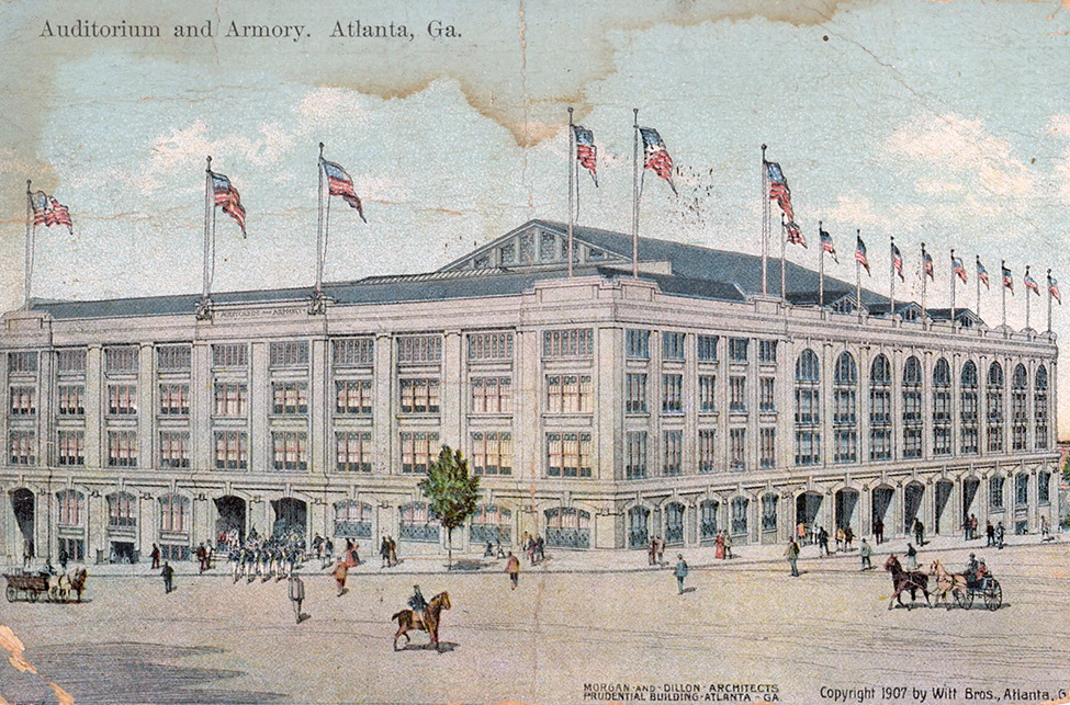
Figure 8. Atlanta’s new Auditorium and Armory as they were completed in 1907. |
One of the first of these ceremonial occasions was the first visit to Atlanta by President William Howard Taft in 1909, when the Chamber of Commerce hosted “a possum dinner” for the President in what was soon christened “Taft Hall” in the nearly-finished complex. In 1910, the New York Metropolitan Opera staged the first of its annuals productions in the Auditorium, and although the stages required some alterations for the staging of grand opera, the Met returned to the Auditorium every year until the Depression forced cancellation of the event in 1931.
By then, the area around the Auditorium, which had looked fresh and new in 1910, was beginning to look increasingly seedy and rundown. One of the old houses on Courtland opposite the Auditorium was still there, as was James Lynch’s second house (ca. 1889) at the corner of Gilmer and Courtland, where his widowed daughter Mrs. Theresa J. Kenny still lived. The rest of the old nineteenth-century houses on Gilmer Street had been demolished and commercial buildings occupied the western third of the block. Especially problematic in terms of civic pride were the used-car lot, “filling station,” and what one contemporary reporter called “a crude parking lot on a bare, rutted hillside” that occupied most of the Edgewood frontage of the Hurt Park site. Since it was along Edgewood Avenue that parades approached the Auditorium from the train depots and the downtown hotels, the condition of the entire block “distressed the civic eye.” [7]
In spite of that, the Depression made it difficult for the City to contemplate any improvements. By the time William B. Hartsfield was sworn in for his first term as mayor in January 1937, the city was $13,000,000 in debt and on the verge of bankruptcy. With the advent of Roosevelt’s New Deal in 1933, the city took advantage of some of the many Federal initiatives that were devised to deal with the Depression, including construction of the country’s first housing project at Techwood in 1935. [8]
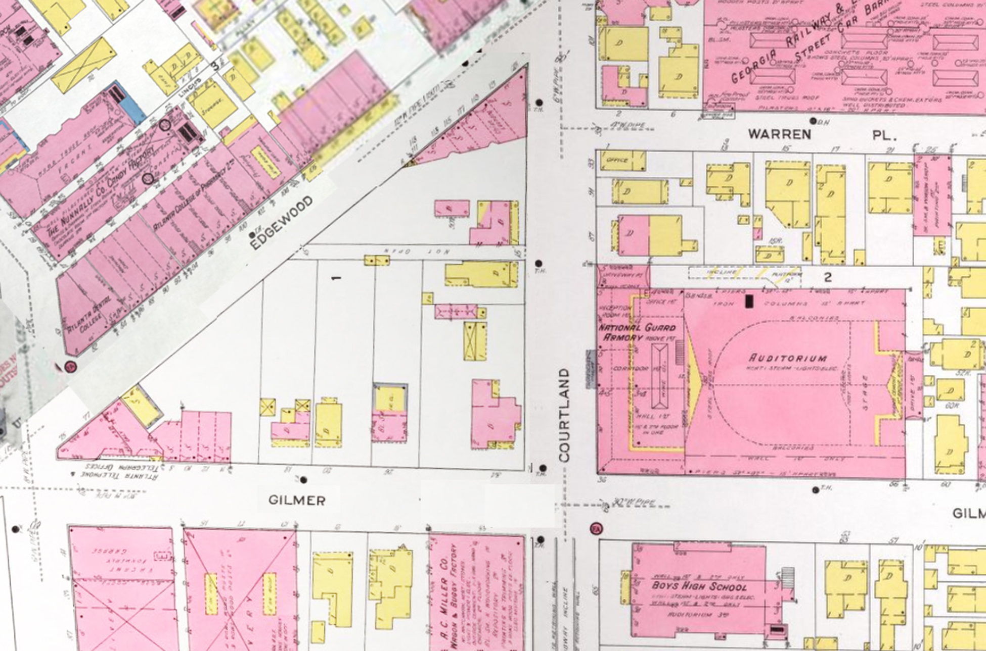
Figure 9. Composite of Sanborn Fire Insurance Company maps of Atlanta in 1911, showing the development that had occurred since Edgewood Avenue was created twenty years earlier. |
In early 1937, the Works Progress Administration (WPA) joined forces with the City to begin a $700,000 remodeling of the Auditorium that included a reinforced-concrete interior and a new steel-trussed, copper-covered roof. Work was not yet complete on 23 August 1937 when a heavy rain caused a large section of the new roof to collapse, flooding the basement and doing some $10,000 in damages to the nearly finished interior. The disaster forced an indefinite postponement of the new auditorium’s dedication, which was scheduled for the following Saturday. A storm of criticism ensued, much of it aimed at the WPA architects, and there were persistent questions about the safety of the entire building. Letting contracts for remodeling of the entrance lobby and exterior of the Armory Building at the front of the Auditorium, which had been scheduled for the next day, were also delayed. [9]
Auditorium Park
Not until the following winter had the controversy surrounding the collapse of the Auditorium roof been resolved so that the project could move forward. By that time, Mayor Hartsfield had interested the WPA in a scheme that would not only complete renovation of the Armory Building but would furnish the City its first downtown park since the original downtown park between Wall and Decatur Streets was sold for commercial development in 1870. In a letter addressed to City Council dated 7 March 1938, Mayor Hartsfield outlined a plan for an “Auditorium park,” noting that “for many years there has been a constant agitation on the part of our citizens for some sort of Central Park.” He noted, too, that there had “been a movement under way for several years to acquire a triangle in front of the Auditorium, which from the standpoint of accessibility and value [seemed] to be about the only reasonable chance of Atlanta acquiring a downtown Park.” [10]
Part of the “agitation” that Hartsfield noted had grown out of the “City Beautiful” movement of the early twentieth century when a number of plans had been put forth to cover over the railroad “gulch” that ran through downtown. One of the best-known of these sometimes grandiose plans was the one presented to the City in 1909 by Atlanta architect Haralson Bleckley. He “envisioned a new street level for Atlanta forty feet above the existing ground level [and the rail-roads] where shoppers and workers could stroll along a pedestrian concourse flanked by palatial buildings.” An expansion of the Bleckley plan was also considered in 1916 but all such plans were consistently opposed by downtown business and real estate interests who saw a grand public plaza over the “gulch” as a waste of money and potential commercial space. Hartsfield tried to revive the idea after he took office but, faced again with opposition, he was never able to go beyond construction of Plaza Park in 1949, which bridged the tracks between Peachtree and Pryor until it was demolished in the mid-1970s. Nonetheless, Hartsfield was committed to improving the appearance of the City, and he was the prime mover behind creation of a “central park and at the same time providing an adequate approach to the new Auditorium.” [11]
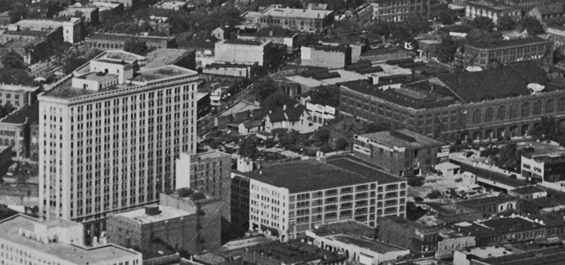
Figure 10. Detail from Parsifal Cobb’s aerial photograph of downtown in 1930. Future site of Hurt Park is at center, with the 1909 Municipal Auditorium and National Guard Armory right of center and the Hurt Building left of center. (Author’s collection) |
Ever the astute politician, Hartsfield may have been largely responsible for pushing the Auditorium park idea, but he made certain that he would have the important business leaders behind the project from the start. At the urging of Hartsfield and the City’s Planning Commission, a “citizens committee” had already been organized to spearhead the project and, in a letter to the Mayor dat-ed 3 March 1938, the committee had outlined their plan to “secure development of an Auditorium park . . . in order to help the City of Atlanta and to improve the neighborhood in which the undersigned are property owners.” The let-ter was signed by committee chairman Ivan Allen Sr., and Richard W. Courts Jr., Bolling Jones Jr., Alvin B. Cates, and W. Brown Hayes. [12]
“Realizing the city has no funds available for the purchase and beautification of the property,” the committee proposed that the City trade the old City Hall site at the northwest corner of Marietta and Forsyth Streets for the Auditorium “triangle” plus $50,000. Alternatively, the committee suggested, the trade could be made with a $25,000 cash “boot,” with the City to share in profits from redevelopment, if it occurred within two years. In order for the committee “to see if the funds can be underwritten by interested property owners to carry the deal through,” they requested that the City grant them a 90-day option on the old City Hall site so that they could proceed with their negotiations. [13]
The principal argument used in support of the deal was the benefit to the City of returning the old City Hall site to the tax rolls. The old United States Post Office and Custom House, which had been built on the site in 1878, had been purchased by the City in 1910 for use as a City Hall. After construction of the present City Hall on Mitchell Street in 1929, the City planned redevelopment of the site and had the old building demolished in 1930. Unfortunately, the Depression ruined the City’s plans and, in 1938, the lot, which encompassed the entire southern half of the block fronting Marietta between Forsyth and Fairlie Streets, remained a surface parking lot. Faced with a dire financial situation, Hartsfield reminded the Council in his letter that the City had even tried “to induce the State of Georgia to take over” the new City Hall so that the City could “move back to the old site,” but that effort failed. As a result, according to Hartsfield, the City had lost “a large amount of taxes on the property.” [14]
Despite the initial enthusiasm generated by the Mayor’s proposal, which included a preliminary plan for the new park, the City Council rejected it, with little discussion, on an 8 to 5 vote. Leading the opposition were Councilman J. Allen Couch and Alderman Ed A. Gilliam, who said that the Marietta Street property was assessed at $500,000 while the proposed park site was valued at only $137,000. Counter arguments were ignored that pointed out that the Auditorium park site was four times as large as and only a block further from Five Points than the City Hall site. Gilliam even introduced a resolution to cancel the leases on the old City Hall site and redevelop it as a park, stating that loss of the $440 per month revenue that the City was receiving from the site would be “nominal.” [15]
In newspaper reports the next day, Hartsfield predicted that “the matter was not ended” and, by the time the Council met again on March 21, he had marshaled his forces again in support of the project. The plan had already been endorsed by the Fulton County Democratic Woman’s Club, the Woman’s Chamber of Commerce, Atlanta Post No. 1 of the American Legion and the Atlanta Hotel Men’s Association. Two days earlier, the Central Marietta Street Association, headed by James D. Robinson Sr., met and unanimously endorsed the project as well, requesting that “City Council give careful and serious consideration to the proposal by the Citizens’ Committee with the hope that a plan can be worked out to develop the park, and also bring the old City Hall site into commercial use.” The signatures on the petition and resolution that were presented to Council on the twenty-first represented virtually every downtown business interest, including the Georgia Power Company, the City’s three major daily newspapers and three of its largest banks, Citizens & Southern, First National, and Fulton National. They were joined by virtually all of the downtown merchants, including Rich’s, Davison-Paxon’s, Woolworth’s, McCrory’s, Kress’, J. P. Allen, Regenstein’s, J. M. High, Beck & Gregg Hardware, Jacob’s Pharmacy Company, King Hardware, Sears-Roebuck and others. [16]
“Yielding to the requests of numerous civic groups and prominent businessmen,” according to newspaper reports the next day, the council approved a motion by Councilman John A. White to reconsider their action in filing the original proposal. As he had earlier, Councilman Couch opposed the motion, stating that he had “not been convinced” of the project’s worth and did not believe that the original proposal had “enough merit” to warrant more consideration. Nevertheless, others urged that the proposal should be “carefully studied,” and, in the end, Council approved White’s motion to refer the matter to their Finance Committee for further study. [17]
A week later, the new Auditorium, repaired and finished at last, was dedicated. “Converted into a showplace of magnificence by the WPA,” the Journal reported the next day, “Atlanta’s City Auditorium returned to central civic life after impressive dedicatory exercises,” which were broadcast live over WGST Radio. Hosted by the City Council, the event was emceed by Councilman John A. White, chairman of the City Council’s Building Committee, who pronounced that, “We are proud of it. It is one of the finest things I ever saw, and is a real tribute to the WPA.” “Conspicuously missing,” the newspaper said, were eleven of the eighteen-member City Council, who did not brave the “heavy rainfall” that afternoon. [18]
The next day, it was announced that the City and the WPA had begun study of “a proposed new $350,000 project at the remodeled City Auditorium calling for renovation of the Armory and construction of a central park as setting for the civic center.” Colonel F. C. Harrington, chief engineer and assistant administrator for WPA stated that his agency would be “glad to consider the two improvements as a single project. . . . This park is something that is badly needed to set off the auditorium. It would be a real contribution to the civic center, and in future years would be an invaluable property.” The newspaper also reported that the combined project “would provide additional convention space at the auditorium, and at the same time fill needs for an adequate armory for the National Guard.” [19]
The fact that Alderman Gilliam chaired the finance committee perhaps insured that the planning would not be rushed and it was not until 21 March 1939 that the a final plan was approved by City Council. Financing the project had remained a sticking point, with the $70,000+ in taxes that had been lost on the old City Hall site since 1930 being a significant part of the equation for the City. During initial considerations of the proposal in 1938, Alderman Gilliam had placed the valuation of the old City Hall site at $500,000 and the Auditorium site at $137,000 and had argued that the deal was a bad one for the City. When the final vote was taken, however, only Alderman Robert Carpenter and Mayor Pro Tem G. Dan Bridges voted “no,” with Bridges continuing to reiterate the argument that the City was not being paid adequately for the old City Hall site. [20]
Perhaps Bridges concerns were valid, since assurances from the “Citizen’s Committee” of 1938 that options had been obtained on the Auditorium park site at 60% of their true valuation evapo-rated in 1939. By that time, the property was acquired on 1 April 1939, the cost of the six parcels that comprised the site had risen to $190,000. On the other hand, it was not until 1954 that the Marietta Street property was finally redeveloped with construction of the old Fulton National Bank Building, which became the City’s largest building and its first major office building since 1930. [21]
A Journal editorial the day after the Council vote called the land exchange “a fortunate deal for Atlanta,” and stated that once the Auditorium triangle was “cleared of its motley buildings and transformed by landscaping and gardening arts,” Atlanta would have “a touch of beauty now sadly wanting.” In addition, the Journal continued, sale and private development of the old City Hall site would convert another “eyesore into productive property” and would enhance development opportunities on the eastern side of downtown. [22]
On 10 April 1939, the Edgemar Corporation, which had been set up and authorized by the Council to facilitate the land exchange, transferred title of the Auditorium “triangle” to the City of Atlanta for ten dollars and “other valuable considerations.” The conveyance was conditioned on the City’s conversion of the property into a public park within six months and “that, until March 15, 1959, be used for public park purposes only.” [23]
The deed also stipulated that the City would widen the streets around the new park “to the extent of not less than ten feet” and to “restore the sidewalks to at least their present condition.” In the conceptual plans that had been presented in 1938, traffic improvements were a signif-icant component of the project and so critical that they were demanded in the deed. Echoing the sentiments of merchants and the rest of the downtown community, Hartsfield had stated earlier that “[o]ur downtown streets are jammed and the slaughter of our people has reached shameful proportions,” go-ing on to note that “[t]raffic is a matter to be handled as a scientific and engineering problem, without political considerations and coupled with rigid enforcement.” Two days later, the City transferred title of the old City Hall site to the Edgemar Corporation for $50,000 “and exchange of properties.” [24]
On 17 April 1939, the City Council authorized demolition of the buildings on the new park site and, one month later, appropriated $15,000 from the proceeds of the land swap to be used “to start development of the park.” The remaining $35,000 apparently went toward a match of the WPA funds being used to renovate the Armory and the entrance to the Auditorium, which the City was anxious to complete since the Auditorium had al-ready been booked for “some of the largest conventions in Atlanta’s entire history.” [25]
The most disruptive part of the project were the street improvements, and that work was underway as soon as the site was cleared. The entire perimeter of the park site was reduced by the widening of the surrounding streets and relocation of the sidewalks by ten feet. In addition, turn lanes and “safety isles,” designed “to minimize traffic congestion,” rounded the east and west ends of the park “triangle” and reduced the Edgewood Street frontage of the site by nearly a third. With the time taken for demolition of the existing buildings, relocation of utilities, and grading and paving the widened streets and new sidewalks, and with financial resources strained, the actual design of the new park may have been delayed until late 1939.
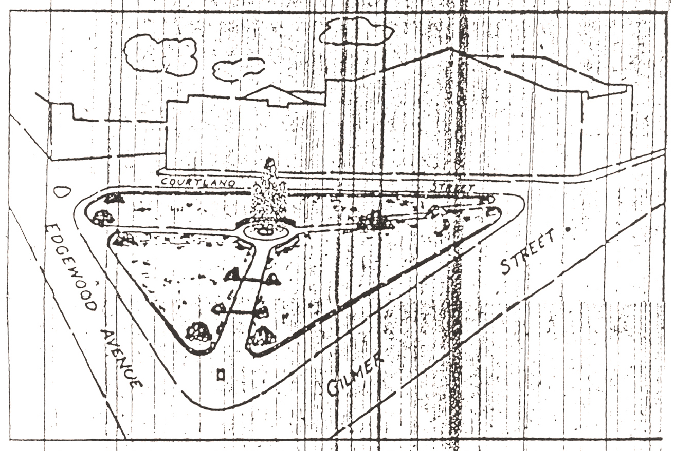
Figure 11. The proposal for the new park as drafted by the city’s planning engineer, Raymond Torras, published in the Atlanta Journal. |
When Hartsfield presented the proposal for an Auditorium park to City Council in March 1938, a preliminary park plan had already been developed and sketched by the City’s planning engineer, Raymond W. Torras. That plan, Hartsfield had said, would create a “beautiful park, with shrubbery, walk-ways, and a modern electric fountain in the center” at a cost then estimated at $35,000. It may not have been until the late fall or winter of 1939, however, that the City engaged the noted landscape architect William C. Pauley to begin development of the final design. [26]
William C. Pauley
The son of Joseph and Lillian Pauley, William Crooms Pauley was born in Lafayette, Indiana, on 6 July 1893. His father was a merchant, and although Joe and Lillian Pauley later divorced, William graduated from Purdue University with a B. S. degree in agriculture in 1916. Two years later, he received a master’s degree in landscape architecture from the Massachusetts Agricultural College in Amherst, Massachusetts, where he also taught drawing.
After service in World War I, he moved to Atlanta with his new German-born bride, Dorothy. They were living in a boarding house on Spring Street near downtown in 1920 when he took his first job in the city, as a draftsman, in the office of the Canadian E. Burton Cooke. By 1921, he was in charge of the Landscape Department at Lakewood Nurseries, which was located about five miles southeast of downtown near the old waterworks at Lakewood. He maintained an office in the Rhodes Building on Marietta Street, and in 1922 or 1923, with his training behind him, Pauley launched his own career. [27]
|
Figure 12. William Crooms Pauley. |
There were very few professional landscape architects in the South at that time; Georgia had only six by 1930. These few were in great demand for the elaborate gardens that were then the fashion for suburban estates in areas like Druid Hills and Haynes Manor in Atlanta and in similar enclaves of the wealthy elsewhere across the state. The design of these gardens was characterized by a mixing of traditional styles—a “creative eclecticism,” according to the noted landscape architect Hubert Owens (1905–1989), who was Pauley’s contemporary—and Pauley’s numerous designs from the 1920s are certainly within that mode. He immediately attracted a wealthy clientele, beginning with J. J. Haverty in 1922 and including Evan and Clark Howell, Beverly DuBose, Fitzhugh Knox, Robert C. Alston, Ernest G. Beaudry, Bolling Jones and many others. Examples of his work in the 1920s included gardens for Harrison Jones’ estate on W. Paces Ferry Road (1922) and for Michael Holt’s spacious lot on Peachtree Circle (1925) as well as elaborate designs for Cam Dorsey’s estate at 2789 Habersham Road (1926), and a woodland garden for the H. C. Heinz estate on Ponce de Leon (1929). Pauley also developed a clientele outside Atlanta, designing private gardens for H. H. Arrington in Rome (1922), M. S. Chipley in Greenwood, South Carolina (1923), William N. Banks Sr., in Newnan (1929), and a variety of other projects in Georgia, South Carolina, and Tennessee. [28]
Pauley continued to design private gardens throughout his career, although after the onset of the Depression, few people could afford the expense and fewer still wanted the sort of elaborate gardens that had been popular in the 1920s. His designs for Robert Woodruff’s residence at 1196 Springdale Road in 1930 includ-ed the entrance to the estate but also included a large “show ring” for Woodruff’s horses. One of his few residential projects in the 1930s was his work for William Elsas and Francis Storza in 1937. An outstanding example of his post-World War II residential work was his 1948 redesign of his earlier landscape at William N. Banks’s “Bankshaven” in Newnan. The design included a large artificial lake, complete with swans, amid a naturalistic setting that provided magnificent vistas from the house.
Pauley had already begun to demonstrate his competence in a wide range of projects in the 1920s, which set him apart from many in the field. Besides the large amount of residential work that he did, especially in the 1920s, Pauley can be credited with designs for numerous schools, colleges, hospitals and nursing homes, public housing, army camps, apartments, airports, cemeteries, churches, clubs, golf courses, hotels and motor courts, subdivisions and a variety of commercial projects. Plans for many, if not most, of his projects are included in collections at the Atlanta History Center and at the Georgia Department of Archives and History. Neither collection has been completely catalogued, but a survey of their contents reveals the range of his work.
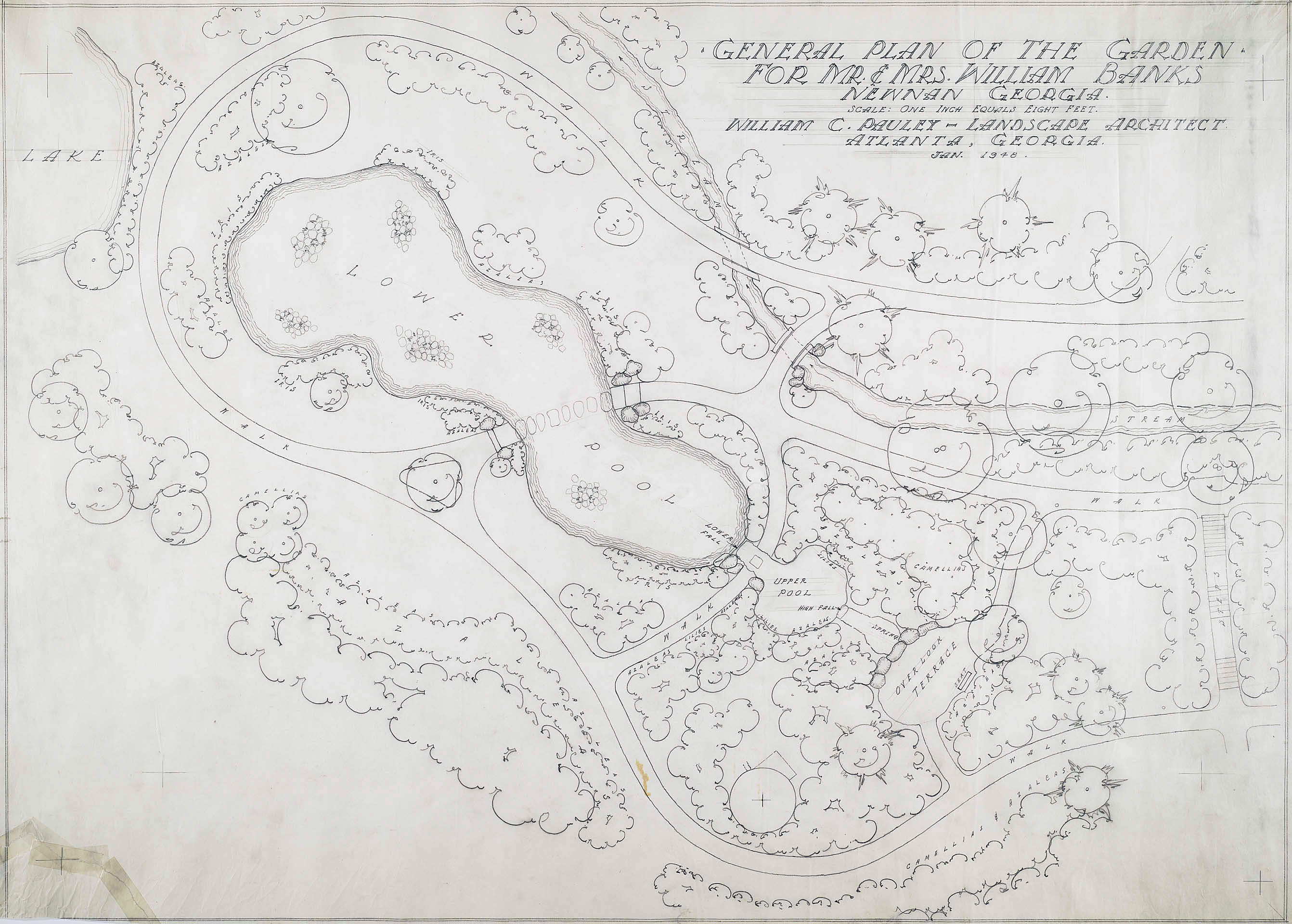
Figure 13. Pauley's plan for the renovation of Bankshaven, 1948. (Georgia Archives and History) |
Pauley’s Atlanta-area school projects included Highland Elementary (1922), Forrest Avenue (1923), E. Rivers with Hentz, Adler, and Shutze (1927), Garden Hills (1938), Chamblee High (1941), Morris Brandon Elementary (1946), Fulton High (1947), Avondale High (1953), Briarcliff High (1957) and many others. He also did the original plan for Rabun Gap-Nacoochee School (1927) and plans for Wesleyan (1928), Georgia Tech (1938), Abraham Baldwin (1951), Columbia Theological Seminary (1952-53), North Georgia College (1952) and West Georgia College (1952), among others. Pauley designed a variety of apartment, hotel and motel projects, beginning with a proposed hotel at Stone Mountain in 1922, which was never built, and the Lookout Mountain Hotel (1927–28) at Chattanooga, and the Peachtree Terrace Apartments (1929) on Peachtree Street in Atlanta. He also provided A. G. Rhodes with a design for a residential subdivision on McDonough Boulevard (1925), which was also not built and became the site of the old Chevrolet assembly plant in 1928, and he designed a subdivision in Tallahassee about the same time. Pauley also did a plan for Sherwood Forest (1945), one of the greatest post-World War II subdivisions within the old city limits of Atlanta.
Pauley’s first hospital project appears to have been at Central State Hospital in Milledgeville (1936) but he also did designs for Egleston Children’s Hospital (1950), Our Lady of Perpetual Help (1954), Jesse Parker Williams (1957), South Fulton (1962) and Athens General (1963). Pauley is also credited with several cemeteries, including Lincoln Memorial Cemetery (1925), an expansion of the College Park Cemetery (1927), Roseland Cemetery in East Point (1933), Crestlawn (1942), and Southview (1964). In addition, Pauley’s work included landscape designs for three of Atlanta’s most prominent churches: St. Phillips (1933, 1945), Christ the King (1950), and Second-Ponce de Leon Baptist (1964).

Figure 14. Plat of Sherwood Forest, which was developed in 1948 from a plan Pauley had done in 1945. (Georgia Archives and History) |
Pauley even did designs for airports at Dublin (1930) and Louisville (1934) as well as at Warner Robins Air Force Base in 1943. In 1961, he designed planting plans for the Atlanta Municipal Airport’s new terminal and, in 1962, for Fulton County’s airport, now Charlie Brown Field.
Park designs, of course, were a large part of Pauley’s career. Although most of them date to the period after World War II, Pauley designed a new park for Newnan, Georgia, as early as 1934 and at Gulf State Park near Mobile, Alabama, in 1936. Later designs include Decatur Park (1944), Pine Lake Park (1945), and Pittman Park (1949), all in the Atlanta area; Bienville Square (1945) in Mobile; and Callaway Mills Park (1947) in LaGrange.
Some of Pauley’s parks included fountains, too, including the magnificent fountain on the square in LaGrange, Georgia. Designed in 1942 but not constructed until after World War II, the La-Grange fountain was also circular and, like Hurt Park, once lit by colored lights and a long cycle of “dancing waters” that drew as much attention in LaGrange as Hurt Park did in Atlanta. In 1976, the historic design was destroyed when a statue of Lafayette on a large octagonal base replaced the fountain mechanism. Only the marble outside walls of the original pool remain intact. Pauley also designed a fountain for Atlanta’s new airport terminal in 1961 but it was destroyed along with that terminal in 1980.
Some of Pauley’s park projects were on a quite large scale. In 1940, while Hurt Park was under construction and after Gone With the Wind inspired new efforts to complete the Confederate memorial at Stone Mountain, Pauley’s preliminary plan for “Stone Mountain Memorial Park” included many features found in the park as it was finally developed in the 1950s and 1960s. Pauley also is responsible for the design and layout of the Zoo at Grant Park as it was redeveloped and expanded between 1958 and 1962. Although most of that design was lost in the dramatic transformations brought to the site by Zoo Atlanta in the 1980s, remnants of Pauley’s walkway layouts and a few other features survive in the present-day zoological park.
In the 1930s, private commissions were severely diminished, and Pauley, like many others, depended on government contracts for much of his work. Concurrently, there was a shift away from the revivalism of earlier eras to a more practical emphasis on use in the late 1930s. As landscape architect Hubert Owens noted, “Style became less of a criterion than function” and Pauley certainly showed himself a part of these “forward-looking” professionals with his design for Hurt Park. This is most clearly evident in the design of the fountain, which did not have the rich detail that might have been expected ten years earlier. Instead, the fountain’s clean, even stark, lines with only subtle modeling of textures and features goes hand in hand with the “Modern Classicism” in architectural design that was also typical of the period. The Federal Post Office Building (1931–33), the Olympia Building (1935–6), the remains of Rhodes Center (1938) and the Plaza Shopping Center (1939) are but the most prominent local examples of this new style.
Pauley was a fellow of the American Institute of Park Executives and of the American Society of Landscape Architects and, in spite of his enormous work-load, was also quite active in a variety of arts and civic organizations. Among these was his service as director and President of Fernbank Forest Association, president of the Druid Hills Civic Association, and as an artist member of the Atlanta Art Association.
After losing his first wife, Pauley married Frances Freeborn Pauley (1905–2003), the daughter of W. W. Freeborn, one of the principles in H. G. Hastings, Inc., the city’s best-known garden center and nursery in the early and mid-twentieth century. A graduate of Agnes Scott College in 1927, she was a social and political activist who set up a free, integrated medical clinic in Decatur in the 1930s and was elected head of the Georgia League of Women Voters in 1951. As League president, she led the fight to overturn the State’s notorious county-unit system and, with her husband’s support, became active in the civil rights movement of the 1950s and ‘60s. To ratify the whispered suspicions that the Pauleys were “integrationists,” the couple even withdrew their membership from the Druid Hills Golf Club in the mid-1950s to protest its “whites only” policy. [29]
William Pauley retired in the late 1960s, after a long and distinguished career. Throughout, according to his widow, he “never thought about money. He was a real artist, a true artist, and that was why his work lived and was pretty as it was.” He died on 9 March 1985 at the age of ninety-one. She died in Lancaster, Pennsylvania, on 16 February 2003 at the age of ninety-seven. [30]
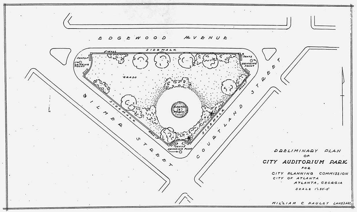
Figure 15. Pauley’s “Preliminary Plan of City Auditorium Park,” probably fall 1939. Note the absence of walkways through the park and the wall that is shown encircling it. (Georgia Department of Archives and History)/td> |
Joel Hurt Memorial Park
Pauley’s preliminary plan for what was still referred to as “City Auditorium Park” was complete by December and showed some significant changes from Torras’ plan. Although it still included an “electric fountain” near the center of the park, Pauley’s plan excluded the walkways shown in Torras’ initial sketch. This may have been because the walks would have been awkward to install on the existing hillside or it may have been that Pauley’s preliminary plan reflected a too-small budget for the project. Pauley initially conceived the park as simply a walled (and inaccessible) green space with the fountain placed part way up the natural hillside of the park. The only other park-like amenities were the benches and “drinking fount” which Pauley showed outside the surrounding wall at each of the three rounded corners of the park.
If funding remained a stumbling block, the City had a benefactor in the Emily and Ernest Woodruff Foundation, which sixty years later remains among the City’s most important philanthropic foundations. In early December 1939, the Mayor received a letter from the Foundation that read, in part:
In the interest of civic advancement and as a mark of respect to the memory of one of the foremost citizens in the history of Atlanta’s progress, the Emily and Ernest Woodruff Foundation desires to offer a gift of $15,000 . . . for the beautification of the park now under construction at Edgewood Avenue and Gilmer Street. It is understood that the plan for the development of the park contemplates the erection of an electrically lighted fountain as the central theme of the park, and the establishment of walkways leading there from the adjacent streets.
In accepting the offer it is requested that the city council take such action as is necessary to cause this park to be designated as the Joel Hurt Memorial Park, and to perpetuate its use for that purpose by such resolution or memorials as may be necessary. [31]
Although the gift was a surprise to most of the City Council, it was immediately accepted. At their regular meeting on December 18, Council passed a resolution naming the new park “Joel Hurt Memorial Park,” a name which had first been suggested by J. J. Haverty and which enjoyed wide support among older Atlantans especially. The Council resolution, which was approved unanimously, also requested that the Legislature place the park “in the list of Parks which can never be sold.” Mayor Hartsfield stated, “This is a splendid thing for the City of Atlanta, and a fine recognition of a man who helped make Atlanta the great city it is today.” The Mayor also noted that it was “especially fitting that this park, in the center of an area that . . . [Hurt] himself developed,” should be named in his honor. With the $40,000 that was included in the 1940 budget for the landscaping and walkways, development of a final plan for the new Hurt Park could move forward, although the total cost of the park would finally reach $85,000.
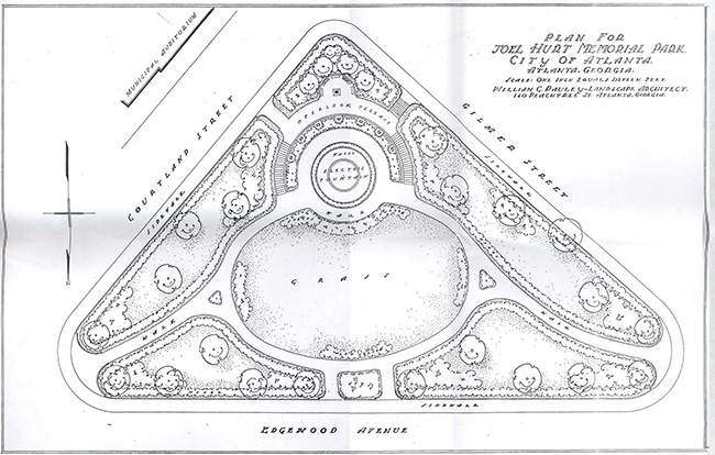
Figure 16. Pauley’s final “Plan for Joel Hurt Memorial Park,” probably completed in December 1939. (Georgia Department of Archives and History) |
By February 1940, Pauley had completed a final design for the park, which incorporated the fountain and the walkways across the park to the main Auditorium entrance. He also drew a grading plan for the park, and work was soon underway resculpting the site to his plan. The natural hillside on which the park would be situated sloped sharply to the north from its high point at Gilmer and Courtland. While this provided a natural elevation for the Auditorium across Courtland,it made the mandated fountain and cross walks difficult to plan. Pauley’s solution was to remove 15,000 cubic yards of dirt, which were dumped “in the big sink hole behind the tennis courts” in Piedmont Park, thus allowing the center portion of the site to be graded to a near-level condition. [32]
Pauley oriented his plan along a principal axis that ran from the park’s main entrance slightly west of the center of the Edgewood Avenue frontage to the high point at Gilmer and Courtland. Along that axis and set back in a “bowl” that was sculpted from the natural hillside is the large fountain that had been a part of the original conceptual plan for the park. To set off the fountain, which he encircled with a concrete-paved terrace, Pauley placed a broad oval “lawn area” near the center of the park, with the lawn and the fountain encircled by concrete walks, eight feet wide, from which other walks radiate to the double-walk park entrance on Edgewood and to each end of the park at Courtland Street and Peachtree Center Avenue.
A marble-faced wall partially encircles the fountain and is inscribed “THIS PARK IS DEDICATED TO THE MEMORY OF JOEL HURT, CITIZEN, ENGINEER, BUILDER, 1850–1926.” This wall acts as a retaining wall behind which semi-circular granite steps rise to the “Overlook Terrace.” From this terrace, additional steps rise to Gilmer Street while a grade level walk leads to Courtland Street opposite the old Auditorium’s main entrance. Simple stone slabs on stone plinths were used to create benches for the park, with three ringing the southeast side of “Overlook Terrace” and seven ringing the terrace around the south side of the fountain.
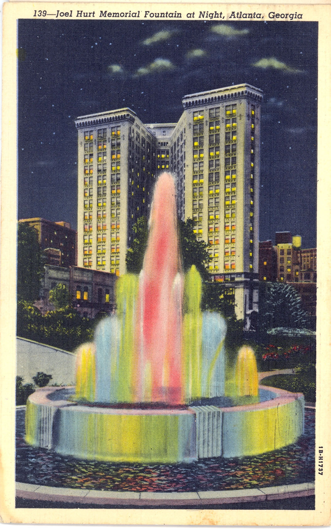
Figure 14. Postcard view of the Hurt Park fountain at nght. (author's collection) |
Pauley’s design for the fountain did not depend on architectural detail for its expression; the actual structure was meant simply as a container for the display that would be provided by the electrically-powered movement and lighting of the water itself. Powerful jets concealed in the center of the bowl of the fountain were operated by a complex electrical mechanism located in a chamber that was placed beneath the fountain and was entered through a door in the retaining wall behind the fountain. This mechanism, which was installed by General Electric Company, sent the fountain through a twenty-minute-long cycle of “dancing waters,” with jets spraying as high as 18’ in an action not unlike that of the popular fountains in Centennial Park today. In addition, seventy-eight light bulbs (ranging from 150 to 1,500 watts and including large floodlights in red, blue, and yellow) lit the entire display from beneath the water, with their constantly changing hues providing additional drama to the cycle of the water jets. According to a report in the Constitution at the time, the fountain was “to be one of the largest and most complete in the entire south” and would produce “one of the most artistic outdoor shows many Atlantans have ever seen.” [33]
While Pauley’s final design for the park did not include the perimeter wall that he showed in his preliminary design, his final design did restrict pedestrian access to the walkways, terraces, and central lawn by fencing the remainder of the site. This fencing created five separate areas around the fountain and lawn which would be planted with trees and shrubs that would partially shield the center of the park from the surrounding streets and accent vistas from within the park. The fencing itself would be largely hidden by an abelia hedge planted against its street-facing side and barberry (Berberis) and Florida jasmine (Jasminum floridum) on the interior-facing sides.
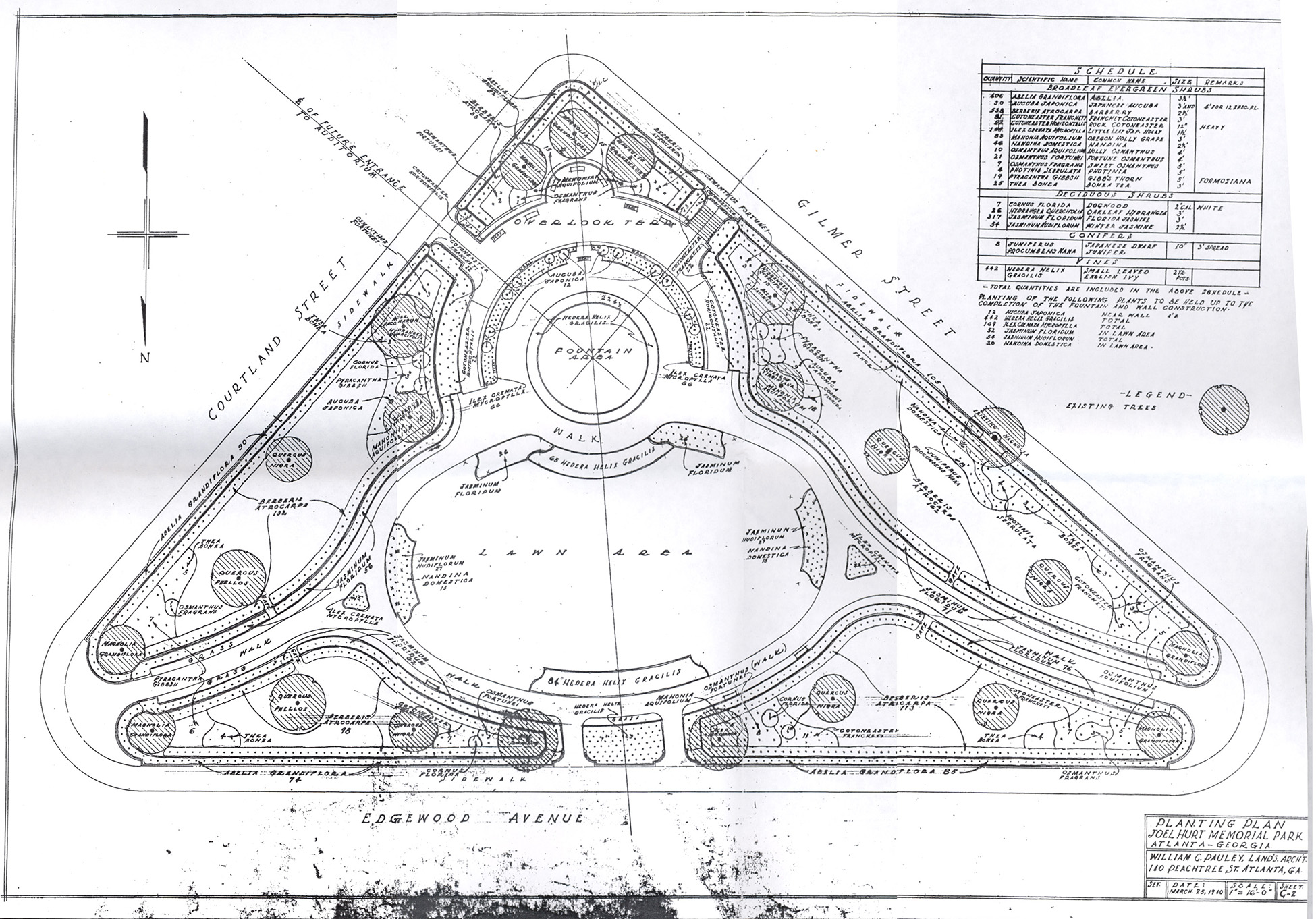
Figure 17. Pauley’s planting plan for the park, dated 25 March 1940. (Georgia Department of Archives and History) |
By the spring of March 1940, Pauley had completed a planting plan for Hurt Park using material that was apparently chosen on the basis of two criteria. The first was that the plants be resistant to urban pollution. Although that term was not used at the time, the newspaper explained:
The shrubbery and the evergreens, as well as the trees, had to be selected especially for the park. Only plants with slick leaves were suitable. Due to the central location, the green things will collect a great deal of dust and soot, which would clog the pores of soft velvety leaves. But every shower and sprinkling will wash the slick leaves clean.
In addition, the plants were selected, in part, to reflect the significant impact that Joel Hurt’s horticultural interests had on the city. He has been credited with being the first to introduce many then-exotic trees and shrubs to Atlanta, including osmanthus (Ozmanthus fragrans), anise (Pimpinella anisum), Japanese magnolia (Magnolia liliiflora), star magnolia (Magnolia stellata), sugar maple (Acer saccharum), which were planted by the dozen out Edgewood Avenue, Japanese red beech (Fagus crenata), live oak (Quercus virginiana), and even a cork tree (Quercus suber) that survived in Springvale Park into the 1950s. One of the most unusual survivors of Hurt’s nineteenth century planting in Inman Park was a large coast redwood (Sequoia sempervirens) that grew in the front yard of his first house on Elizabeth Street and flourished into the 1980s. [34]
Work was underway to secure the twenty-one trees that Pauley had specified for the site. In order to put on the best effect, large trees were ordered, including seven magnolias which were meant “to match the fine old” magnolia that had been planted in James Lynch’s front yard in the nineteenth century and which survived next to the sidewalk opposite the Art Department on Gilmer Street until the early twenty-first century. Suitable trees were ultimately found throughout the state, including at Winder, Hogansville, Forest Park, Chamblee, and Smyrna and with equipment that had been used at the New York World’s Fair the previous year, the trees were transplanted to Hurt Park. [35]
The seven magnolias were used at each of the three corners of the park, with two trees flanking the Courtland/Edgewood entrance, two flanking the Gilmer/Edgewood entrance, and a trio completely obscuring the southeast corner of the park behind the fountain. The live oaks that Pauley specified for Hurt Park were a particular problem since they are not native to the Georgia Piedmont. In fact, many believed that they could not survive in the Piedmont at all until Joel Hurt demonstrated otherwise with the numerous live oaks that were successfully planted in Inman Park in the late 1880s and early 1890s. In part due to the extremely dry summer that occurred in 1940, the first live oaks in Hurt Park did not survive their three-year guarantee and had to be replanted. A pair of sugar maples (Acer saccharum) was used as an accent on either side of the double entrances on Edgewood and another pair accented the Gilmer and Courtland Street entrances. Two willow oaks (Quercus phellos) flanked the walkway to the corner of Edgewood and Courtland while six water oaks (Quercus nigra) were used to complete the planting of large trees.
|
Figure 18. Pauley’s construction plan for the park, dated February 1940. (Georgia Department of Archives and History) |
The plant list for Hurt Park was not extensive in its variety but it did include 21 mature trees; nearly 1,500 broad-leafed evergreen shrubs, 3’ to 5’ tall; and over 400 deciduous shrubs, 2’ to 3’ high. The most numerous of the shrubs were the abelia (Abelia grandiflora) that outlined the perimeter of the park and the barberry (Berberis thunbergii f. atropurpurea) and Florida jasmine (Jasminum floridum) that hid the fencing of the planting beds inside the park. With these perimeters established, Pauley placed informal beds flanking each of the entrances to the park and planted them with osmanthus (Osmanthus fragrans), cotoneaster (Cotoneaster horizontalis and franghett), pyracantha (Pyracantha gibbsii), mahonia (Mahonia aquafolium), tea (Thea bohea), oak-leaf hydrangea (Hydrangea quercifolua), acuba (Aucuba japonica), and winter jasmine (Jasminum nudiflorum). Around the old Lynch magnolia at the Gilmer Street sidewalk, he designed a small bed that included nandina and tea olive that he used elsewhere in the park but to which were added eight dwarf juniper (Juniperus procumbens) and four photinia (Photinia serrulata), neither of which are found elsewhere in the park. The remainder of the beds were then left open for planting of flowering bulbs and annuals.
In addition to the five large beds along Edgewood, Courtland, and Gilmer, Pauley created smaller beds within and around the central lawn area. Outlined by a specially-designed metal edging, these beds were planted with nandina, jasmine, and small-leafed English ivy (nearly 450 pots), each for the season of their bloom or, in the case of the ivy, for their winter display of bronzed foliage. Finally, Pauley used a dwarf Japanese holly (Ilex crenata) around the perimeter of the fountain terrace and in the small circulation islands at each end of the lawn area.
By November 1940, the park was nearing completion and November 24 had been set as the date for its dedication. The Atlanta Constitution editorialized that “[t]he landscape architect, William C. Pauley, is to be congratulated upon the very excellent vision with which he transformed a barren, ugly hillock into a rolling, graceful, and beautiful park.” Across the street, the old, red-brick Armory building had just had its “face lifted with a new coat of ivory stucco, selected by the architects to match the park.” [36]
Again, however, disaster struck the City’s new civic center, when on the night of 11 November 1940, just a week after Hartsfield suffered his first and only defeat in the mayoral elections, the Armory was destroyed by fire. A dance was being held in the Auditorium and there were a few people in the National Guard quarters in the Armory when the fire broke out, but the conflagration quickly went out of control. Although everyone was herded to safety, the Armory roof soon collapsed and the entire building was a scorched ruin by morning. A masonry fire wall between the Armory building and the Auditorium and the latter’s new copper roof prevented damage there but the Armory and the Courtland Street entrance to the Auditorium were a total loss. [37]
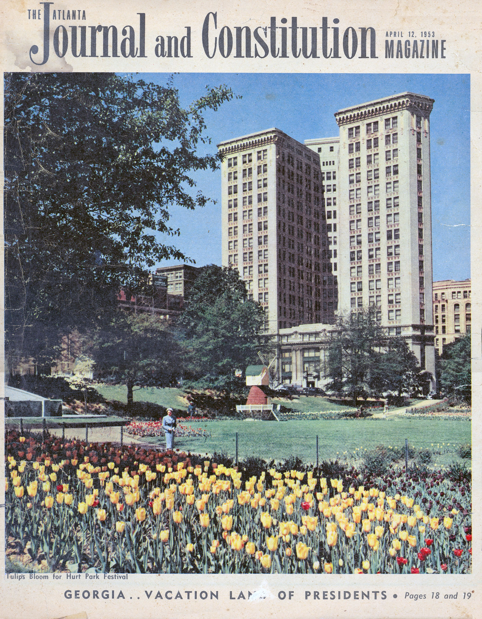
Figure 19. Plat of Sherwood Forest, which was developed in 1948 from a plan Pauley had done in 1945. (Georgia Archives and History) |
The fire even scorched some of the newly planted trees across the street in Hurt Park but there was not time to replace them or to make any repairs to the front of the Auditorium and the park dedication went on as scheduled. However, the “gaunt” walls of the Armory building, which still stood after the fire, did force the City to cancel plans to flood light the Auditorium complex as a backdrop to the event. Instead the flood lights were focused on the park itself, while the Hurt Building was lit “from basement to cornice, and added to the brilliance of the observance.” [38]
The ceremonies were directed by Mayor Hartsfield and attended by Joel Hurt’s widow and other family members; Emily and Ernest Woodruff and trustees of their foundation; city officials and hundreds of others who “defied the rains” that were falling that afternoon. Promptly at 5:00 PM on 23 November, Mayor Hartsfield began the ceremonies, which included a number of different speakers. Pauley himself was among the first to speak, explaining his design and noting that “many of the trees and shrubs used were ones brought to Atlanta by Mr. Hurt.” Pauley then presented the keys to the fountain to Thomas K. Glenn, president of the Woodruff Foundation, who delivered the keynote address for the event and presented the keys to Mayor Hartsfield. George L. Simons, city parks manager, and Councilman Cecil Hester formally accepted the fountain for the City, with Simons commenting that he had dreamed of an electrical fountain for the Atlanta park system “for the past 10 years and now that dream has come true with this splendid gift in memory of a great Atlantan.”
Ernest Woodruff, who was Hurt's brother-in-law, was the final speaker and “faced the microphone to say that he was both happy and pleased.” At his signal, sixteen-year-old Jane Hurt, the youngest of Joel Hurt’s granddaughters, threw a switch and the fountain “blazed into light and cascading waters.” The dedication of “Atlanta’s only downtown park, the most beautiful and artistic of all the city’s recreation and beauty spots,” was complete. [39]
At its next meeting, on 25 November 1940, the City Council adopted an ordinance accepting the park and outlining the conditions for its use:
An ordinance providing that Joel Hurt Memorial Park bounded by Courtland, Gilmer, Ivy, and Edge-wood be and it is hereby declared to be a memorial park dedicated to the memory of Joel Hurt, pioneer Atlanta citizen, and as such Park, it shall be unlawful to use the same for playground purposes or to work injury or damage in any manner in said Park, the fountain or trees or shrubbery therein. It shall further be unlawful to install, erect or place therein any sort of monument, marker, tablet, sign or advertising matter in conflict with the dedication and use of said area as a Memorial Park to the memory of said Joel Hurt. [40]
Civic Center
Hurt Park opened to enthusiastic reviews in the local press and, the day after its dedication, a special organ concert was arranged in the Auditorium with the sound carried through loudspeakers outside so that “those who wish to see the fountain in operation to organ music may do so.” Many did and, although the organ recitals were a one-time event, Hurt Park remained an immensely popular attraction in downtown Atlanta.
Significantly, Pauley’s design for Hurt Park set the precedent for other major buildings that were built on the south and east sides of the park in the 1940s and early 1950s. In 1943, the old Armory, today owned by Georgia State University and known known as Alumni Hall, was refaced with marble after its near-destruction by fire a week before the park was dedicated in November 1940. The USO building just to the north was refaced with marble in a similar design as well. In 1949, marble was used in construction of the now-lost Atlanta Fire Department Signal Department in the lot at the southeast corner of Courtland and Gilmer, which had remained undeveloped when old Boys High burned in 1924. Finally, between 1952 and 1955 came Sparks Hall (1952–5), its ribbons of windows set over ribbons of white marble. [41]
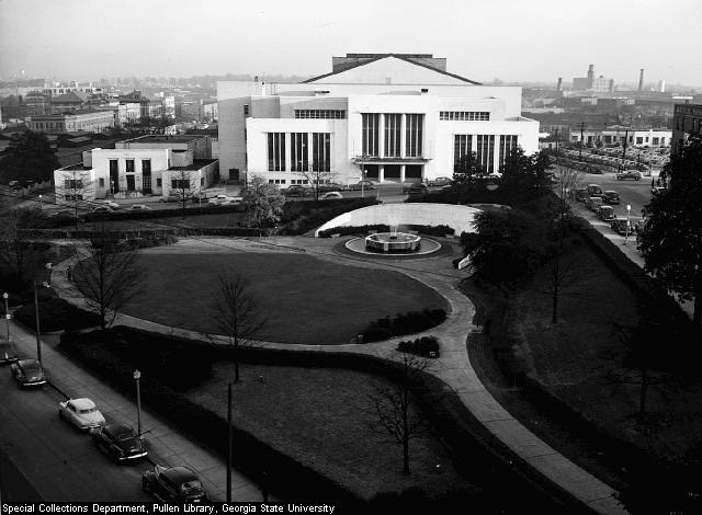
Figure 20. Hurt Park and Municipal Auditorium in 1950. (Lane Brothers Collection) | 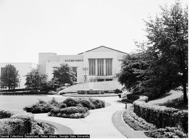
Figure 21 Hurt Park and Municipal Auditorium in 1950. (Lane Brothers Collection) |
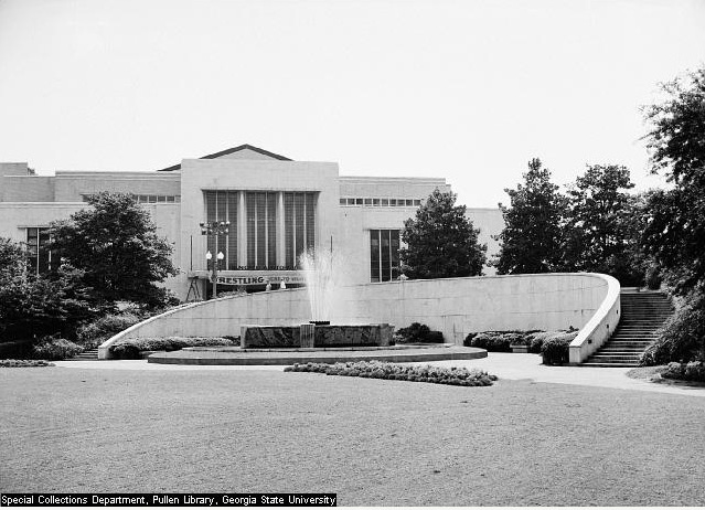
Figure 22. Hurt Park fountain and Municipal Auditorium in 1950. (Lane Brothers Collection) | 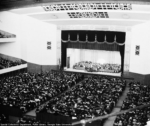
Figure 23. Interior of Municipal Auditorium in 1955. (Lane Brothers Collection) |
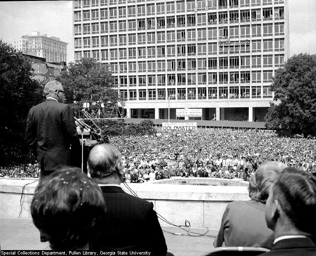
Figure 24. Campaign rally for Barry Goldwater in Hurt Park in 1964. (Lane Brothers Collection) |
Figure 25. Hurt Park and the rear of the Hurt Building in 1950. (Lane Brothers Collection) |
|---|
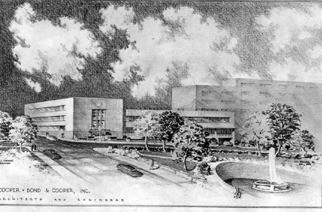
Figure 26. Design for Sparks Hall, 1950. (Lane Brothers Collection) |
|---|
During World War II, the location of the USO across Courtland next to the Auditorium brought hundreds of GIs to the park to visit with their families and friends. One of these men was so enamored of the Hurt Park fountain that, when he was shipped overseas in 1943, he took with him not only a photo of his fiancé but also a colored post card view of Hurt Park. In 1946, the couple was married in the park in what the newspaper called the city’s “most spectacular public wedding” and 16,000 people watched as Mayor Hartsfield himself gave away the bride. [42]
By the end of the War, Hurt Park’s reputation was firmly established. “At night,” the Journal reported in 1946, “the play of rainbow colors in the star-reaching spray is an attraction for whole families to drive downtown just to let the children watch the lights and colors come and go in the mist.” Whether they came to eat lunch, “waller in the grass” or just sit in their cars along Edgewood Avenue and watch the fountain’s display, Hurt Park and its “miracle of leaping waters and changing colors,” as one reporter described the fountain, quickly became a favorite of a generation of Atlantans. As Atlanta author Celestine Sibley wrote, it was “an authentic Sight and Wonder” and “we hauled all visitors to see it.” [43]
In the spring of 1946, Atlantans were also treated to the first of what became an annual “Tulip Festival” in Hurt Park. Over 40,000 bulbs, a gift of the Dutch government and Holland, Michigan, were planted in the fall of 1945, producing a spectacular display like many Atlantans had never before seen. The Festival even included a replica of a Dutch windmill and made the Park a popular destination each spring through the 1950s. [44]
Also in 1946, the school that would become Georgia State University moved from Luckie Street to the Bolling Jones Building at 124 Ivy Street (now Peachtree Center Avenue) across from Hurt Park. Its presence and subsequent growth brought a new set of regular visitors to the Park and made the Park an even more vital part of the City’s landscape.
There were alterations to the plantings in the park at an early date, beginning with the annual tulip festival. The City Parks Department was constantly “retouching” the park, planting flowers and replacing shrubbery. In a major replanting in 1948, the City’s Parks Department added chrysanthemums and 1,700 azaleas which would be “comparable in color” to the popular tulip festival. [45]
Decline and Neglect
By the end of Hartsfield’s extraordinarily long career as Mayor in the 1960s, plans were underway for a new civic center to replace the ageing facilities across from Hurt Park. Opened on an old Urban Renewal site north of downtown in 1968, the present Civic Center and the great convention facilities that were begun on Marietta Street in the 1970s quickly sapped the life from the Auditorium and, to a certain extent, Hurt Park itself. The students remained, however, as did office workers from the AT&T, Hurt, and other nearby office buildings and, in 1980, the City refurbished Hurt Park. The walkways and other parts of the hardscape were not changed but it appears that, if any of Pauley’s original shrubbery had survived, it was completely replaced with “hundreds of azaleas.”
The fountain was put back into operation, too, for a brief interval but problems with ageing equipment and the constant tinkering and adjustments that were required for it to operate properly proved to be an expense that the City was unwilling to bear. As a result, the fountain has not operated in over fifteen years and, unfortunately, most of the internal equipment that drove the water and light display has now been removed. The door to the underground control room has been removed as well, the opening sealed, and only the colored floodlights and other underwater light fixtures remain in place. The same thing also happened to Pauley’s fountain in LaGrange, when appreciation of the brash colors and effects of the Art Moderne reached a low ebb in that city in 1976. [46]
Today, virtually all of the hardscape that was designed and installed under the supervision of William Pauley remains in place. The walkways, which were poured with a pea-gravel aggregate in a rose-colored concrete, are in remarkably good condition throughout the Park and have not been altered except in isolated areas around drains and water fountains. The granite seating and steps around the fountain terrace and “Overlook Terrace,” too, remain in place although the setting of some of the steps has deteriorated. The fountain and its surrounding memorial wall are dirty and stained but intact except for two slabs of marble that are missing from the sides of the fountain.
A few additions have been made to the Park in recent years, including granite signs announcing “Hurt Park at Georgia State University” which have been placed at the Park’s Edgewood Avenue entrances and a series of light standards that have been installed around the perimeter of the lawn. A piece of modern sculpture stands alone and unlabeled near the eastern end of the Park. Just west of the center of the Edgewood Avenue entrances, an area measuring approximately 9’ by 29’ has been enclosed by a 40”-high concrete wall which shields banks of floodlights lighting the Woodruff Foundation building across the street.
In 1998, most of the original trees remained in place, including the very tall magnolia along Gilmer that had been planted over a hundred years ago in what was then the front yard of James Lynch’s house. Stumps on the bank along Gilmer Street marked the locations of a water oak, a live oak, and a sugar maple that were part of the original planting, with the sugar maple having been removed that same year. The other missing live oak on the east side of the fountain has been replaced with a sugar maple while the two sugar maples that originally flanked the Edgewood entrances were replaced by Japanese magnolia in 1980. Although they survive, many of the trees have been “limbed up.” This has destroyed a significant aspect of Pauley’s original design which had the intent of shielding the lawn and interior of the Park from the busy surrounding streets.

Figure 27. The western end of Hurt Park after the tornado in March 2008. (author's photograph) |
On 29 March 2008, an F2 tornado swept across downtown Atlanta, clipping the eastern end of Hurt Park with winds as high as seventy miles an hour as it moved in a east-southeasterly direction across the city. At that end of the park, one magnolia was uprooted and another badly damaged, as was the Lynch magnolia on Gilmer Street which lost half of its crown and was subsequently removed.
In addition, the central lawn remains intact, but the beds that Pauley placed around the edges of the lawn have been eliminated and, with the possible exception of a few badly-overgrown osmanthus, virtually none of the Park’s original shrubs remain in place. Even many of the azaleas that were planted in 1980 are gone and large areas of the Park have no shrubbery or ground cover at all. To the casual observer or passing motorist, Hurt Park appears much as it always has, with the dead fountain being perhaps the most noticed change. On closer inspection, however, the present landscape of the site is but a shadow of what it was historically. Not only are the distinctive shrubs and flowers no longer planted, but changing use patterns downtown have meant that the Park is no longer a promenade to anywhere, especially since the Auditorium was sold by the City and demolished in the late 1970s. Nevertheless, most of the significant features of Hurt Park remain intact and it is eligible for listing in the National Register of Historic Places. Not only is Hurt Park significant for its design and its associations with William C. Pauley, it also represents an important point in Atlanta’s history when Hartsfield and others with a vision for the City’s future created its first civic center.
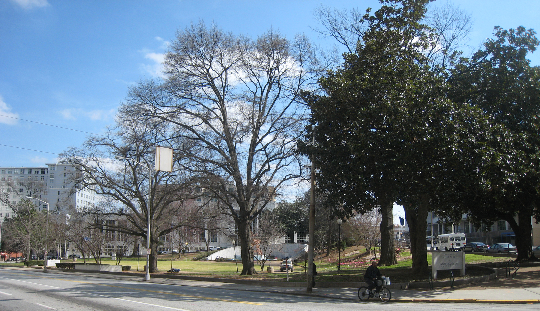
Figure 28. Joel Hurt Memorial Park, 2008. (author's photograph) |
![]()
Acknowledgements
Thanks go to archivists at the Pullen Library’s Special Collections, which holds important early images of the site in its collection, to the Atlanta History Center, which holds an important collection of Pauley plans and whose file of newspaper clippings on Hurt Park were a real time-saver; and to the Georgia Department of Archives and History which holds the many sheets of original drawings relating to the design and construction of Hurt Park as well as many of Pauley’s other plans. Research was greatly expedited by Spencer Tunnell, who is in the process of publishing a paper on the career of Wil-liam Pauley and who kindly pointed me toward important sources of information. And a special thanks for Dr. Timothy J. Crimmins for his constant support.
![]()
Notes
1. Obituary of James Lynch, 16 May 1899; abstracted in Franklin Garrett’s “Necrology,” Atlanta History Center. Franklin Garrett, Atlanta and Environs (University of Georgia Press, 1954), Vol. 1, 256–257; Vol. II, 188. Vivian Price, The History of DeKalb County, Georgia, 1822–1900 (Wolfe Publishing Co., 1997), 280-287. U. S. Census, 1850, DeKalb County. James Michael Russell, Atlanta, 1847-1890: City Building in the Old South and the New (Baton Rouge, Louisiana State University Press, 1988), 43, 84, 87–8. Also see Fulton County Superior Court Records of Deeds and Mortgages, Books O-467, DD-210, KK-620, and TT-28.
2. Thomas K. Glenn, “Joel Hurt (1850–1926),” Atlanta Historical Bulletin, XXV (July 1941), 216; Sarah Sims Edge, “Joel Hurt and the Development of Atlanta,” Atlanta Historical Bulletin, IX (1955).
3. Rick Beard, “Hurt’s Deserted Village,” Olmsted South: Old South Critic/New South Planner. (Westport, Conn.: Greenwood Press, 1979), 201–2.
4. Fulton County Deed Book TTT, 536.
5. Edge, “Joel Hurt,” 105.
6. “Auditorium Was Built in 1906 With Funds Raised by Citizens,” Atlanta Constitution, 12 November 1940, 1; Garrett, Vol. II, 493.
7. Willard Neal, “25 Years in One Summer,” Atlanta Journal Magazine, November 3, 1940, 3; . Katherine Pierce, “Beauty in the Business Section,” Atlanta Journal Magazine, May 12, 1946, 16.
8. Harold M. Martin, William Berry Hartsfield (Athens: University of Georgia Press, 1978), 21; Garrett, II, 950.
9. Atlanta Constitution, 24 August 1937.
10. Garrett, Atlanta and Environs,” Vol. 1, 838–839; see Atlanta City Council Minutes, 7 March 1938, for full text of letter.
11. Howard Preston, Automobile Age Atlanta. (Athens: University of Georgia Press, 1979), 118–119; City Council Minutes, 7 March 1938.
12. The text of the committee’s letter to the Mayor are included in the City Council Minutes for 7 March 1938. Both the Mayor’s letter and the committee’s letter are quoted in their entirety in the Atlanta Journal 6 March 1938.
13. “Park Setting for Auditorium Suggested to Mayor Hartsfield,” Atlanta Journal, 6 March 1938, 2-A.
14. City Council Minutes, 7 March 1938.
15. “Trade of Old City Hall Site for Park Defeated by Council in 8-to-5 Vote,” Atlanta Constitution, 8 March 1938.
16. “Atlanta Business Leaders Join in Urging Auditorium Park,” Atlanta Journal, 20 March 1938.
17. “Park Plan for Auditorium Park Reconsidered by Council,” Atlanta Constitution, 22 March 1938.
18. “City Auditorium Acclaimed After Impressive Dedication,” Atlanta Journal, 28 March 1938.
19. “City and WPA Study Plan for Auditorium Park,” Atlanta Journal, 28 March 1938.
20. “Auditorium Park Exchange Okayed,” Atlanta Constitution, 21 March 1939.
21. Fulton County Deed Records, Book 1719, 343–4; Book 1732, 344, 429, 448, 451–2, 469.
22. “A Fortunate Deal for Atlanta,” Atlanta Journal, 22 March 1939.
23. Fulton County Deed Book 1732, 414.
24. Martin, William Berry Hartsfield, 21; Fulton County Deed Book 1732, 460.
25. City Council Minutes, 17 April, 15 May 1939; “Auditorium Park Exchange Okayed,” Atlanta Constitution, 21 March 1939.
26. “Park Setting for Auditorium Suggested to Mayor Hartsfield,” Atlanta Journal, 6 March 1938. The exact date at which William C. Pauley was engaged to design the park is not known, but his preliminary design, which is undated, refers only to “City Auditorium Park” and so must predate the formal naming of the park in December 1939.
27. “William Pauley, 91, landscape architect,” obituary in Atlanta Constitution, 10 March 1985; Atlanta City Directories, 1919-1923; dates on plans.
28. Hubert R. Owens, Personal History of Landscape Architecture in the Last Sixty Years 1922-1982. (Athens, 1983), 10.
29. “Capitol Crusader,” Atlanta Constitution, 1-E, 13 January 1989.
30. Telephone interview with Frances Pauley, 6 September 1998.
31. City Council Minute Books, 18 December 1939; “Woodruff Foundation Gives $15,000 for Joel Hurt Park,” Atlanta Constitution, 19 December 1939. City Council Minute Books, 18 December 193; 9. “Joel Hurt Park is Suggested as Name of Downtown Tract,” Atlanta Journal, 18 December 1939.
32. “25 Years in One Summer,” Atlanta Journal Magazine, 3 November 1940.
33. “Atlanta’s Fountain of Light,” Atlanta Journal Magazine, 12 January 1941. Most accounts state a 20-minute cycle for the fountain’s display but cycles of 30 minutes and 12 minutes have also been reported. “Joel Hurt Park To Be Opened On Saturday,” Atlanta Constitution, 21 Nov 1940.
34. Sarah Sims Edge, “Joel Hurt and the Development of Atlanta,” Atlanta Historical Bulletin IX (1955), 131–132.
35. “25 Years in One Summer,” Atlanta Journal Magazine, 3 November 1940.
36. “Oasis of Beauty,” editorial in Atlanta Constitution, 26 November 1940.
37. “Raging Fire Sweeps Auditorium; $150,000 Army Supplies Destroyed,” Atlanta Constitution, 12 November 1940.
38. “Hundreds Defy Rain to Witness Hurt Fountain Dedication,” Atlanta Constitution, 24 November 1940.
39. No record has been located of Pauley’s comments at the dedication but Thomas Glenn’s keynote address and other tributes to Joel Hurt were reprinted in “Joel Hurt Memorial Park,” Atlanta Historical Bulletin IX (1955), 328–339.
40. City Council Minutes, 25 November 1940; Ordinance Book 28.
41. See Robert M. Craig, Atlanta Architecture, Art Deco to Modern Classic, 1929-1959. (Gretna, LA: Pelican Publishing Company, 1995).
42. “16,000 See War Dreams Come True for Ex-GI, Bride at Hurt Park,” Atlanta Constitution 22 March 1946; “Most Spectacular Public Wedding,” Atlanta Journal & Constitution Magazine, 14 July 1963.
43. “Lunch in the Sun,” Atlanta Constitution, 21 May 1944; “Beauty in the Business Section,” Atlanta Journal Magazine, 12 May 1946; “Hurt Park’s Old Charm is Coming Back,” Atlanta Constitution, 17 November 1980.
44. “30,000 Tulips to nod in Hurt Park,” Atlanta Constitution, 19 June 1945, 3; “Tulip Bulbs Arrive for Hurt Park,” Atlanta Constitution, 18 November 1947; Atlanta Journal and Constitution Magazine, 12 April 1953.
45. Atlanta Constitution, 31 May 1948.
46. The original colored light display at Pauley’s fountain in LaGrange was also removed from that fountain in 1976.
![]()
Sources of Information
Published Sources
Atlanta Constitution.
Atlanta Journal.
Beard, Rick. “Hurt’s Deserted Village: Atlanta’s Inman Park, 1885-1911,” Dana F. White and Victor A. Kramer, eds., Olmsted South: Old South Critic/New South Planner. Westport, Conn.: Greenwood Press, 1979.
Craig, Robert M. Atlanta Architecture, Art Deco to Modern Classic, 1929-1959. Gretna, LA: Pelican Publishing Company, 1995.
Edge, Sarah Sims. “Joel Hurt and the Development of Atlanta.” Atlanta Historical Bulletin, IX (1955). Garrett, Franklin. Atlanta and Environs, 1954. Reprint, Athens: University of Georgia Press, 1969.
Glenn, Thomas K. “Joel Hurt (1850-1926),” Atlanta Historical Bulletin, XXV (July 1941).
Martin, Harold M. William Berry Hartsfield. Athens: University of Georgia Press, 1978.
Owens, Hubert R. Personal History of Landscape Architecture in the Last Sixty Years 1922-1982. Athens: Uni-versity of Georgia Alumni Association, 1983.
Preston, Howard L. Automobile Age Atlanta: The Making of a Southern Metropolis, 1900–1935. Athens: University of Georgia Press, 1979.
Russell, James Michael. Atlanta, 1847–1890: City Building in the Old South and the New. Baton Rouge: Louisi-ana State University Press, 1988.
Shavin, Norman, and Bruce Galphin. Atlanta, Triumph of a People. Atlanta: Capricorn Corporation, 1982.
Spalding, Phinizy. Georgia: The WPA Guide To Its Towns and Countryside. Columbia, S. C.: University of South Carolina Press, 1990.
Public Records
Atlanta City Council Minute Books, 1937-1940.
Fulton County Superior Court, Deed Rec-ords, 1854-1942.
Maps
Ruger, A. A Bird's-eye View of the City of Atlanta, the Capital of Georgia, 1871. A. Ruger & Co., St. Louis, MO. Modern reprint.
Sanborn Fire Insurance Maps, 1886, 1892, 1911, 1931.
Saunders, H. G., Bird’s-Eye View of Atlanta, 1892. Atlanta History Center.
Vincent, E. A., “Old Map of Atlanta,” as reprinted in Hopkins Atlas of Atlanta, 1878. Atlanta History Center.
Architectural Drawings
Original blueprints and drawings for Hurt Park are in the William C. Pauley collec-tion at the Georgia Department of Ar-chives and Records. A collection of Pauley plans can be also be found at the Atlanta History Center. Both collections are currently uncatalogued.
Oral Interviews
Mrs. Frances Freeborn Pauley, widow of William C. Pauley, 6 September 1998.
Mr. Spencer Tunnell, landscape architect, 4 August 1998.
| top |
|---|